
BS GEODETIC ENGINEERING
The Bachelor of Science in Geodetic Engineering at the University of the Philippines is a four-year program that provides a thorough grounding in geodetic and geomatics engineering, including surveying, remote sensing, geographic information systems, global navigation satellite systems, geospatial computations, land development and valuation, and laws.
OVERVIEW
Surveying education in the Philippines began with the Bureau of Public Lands' School of Surveying, initially a two-year program. In 1925, it merged into the UP College of Engineering, awarding an Associate in Surveying degree. By 1937, it expanded into a five-year BS in Geodetic Engineering, leading to the establishment of the Department of Geodetic Engineering.
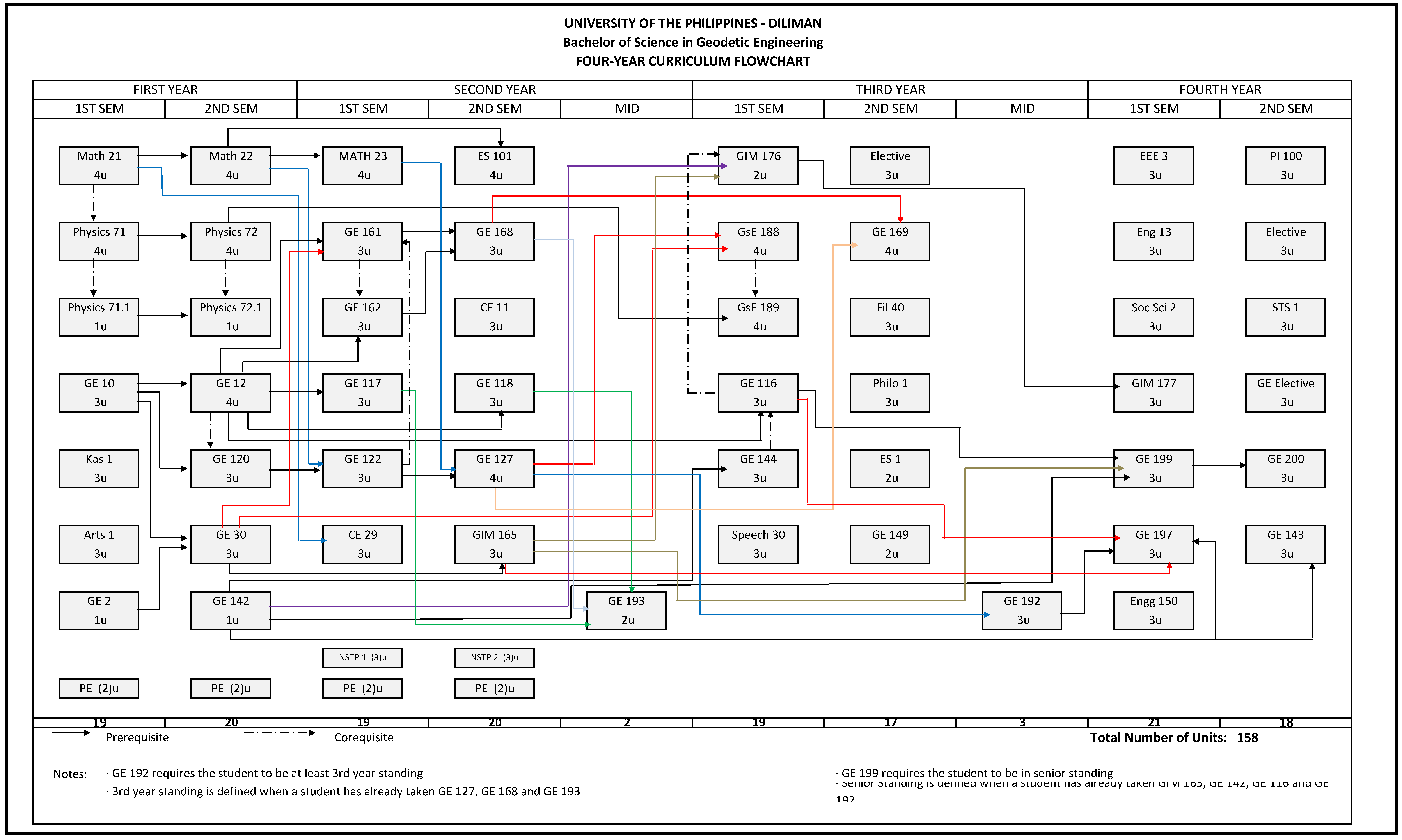
Since 2010, the curriculum has been refined, with minor updates in 2012 and 2016 to align with the UP Diliman General Education Hybrid Program. The current four-year, 158-unit curriculum, implemented in 2019, integrates geomatics, general education, and technological advancements to meet evolving societal needs.
STUDY PLAN
1st Semester
Math 21
Physics 71
Physics 71.1
GE 10
Kas 1
Arts 1
GE 2
PE
1st Year
2nd Semester
Math 22
Physics 72
Physics 72.1
GE 12
GE 120
GE 30
GE 143
PE
1st Semester
Math 23
GE 161
GE 162
GE 117
GE 122
CE 29
PE
NSTP 1
2nd Year
2nd Semester
ES 101
GE 168
CE 11
GE 118
GE 127
GIM 165
PE
NSTP 2
1st Semester
GIM 176
GsE 188
GsE 189
GE 116
GE 144
Speech 30
3rd Year
2nd Semester
Elective
GE 169
Fil 40
Philo 1
ES 1
GE 149
1st Semester
EEE 3
Eng 13
Soc Sci 2
GIM 177
GE 199
GE 197
Engg 150
4th Year
2nd Semester
PI 100
Elective
STS 1
GE Elective
GE 200
GE 143
Midyear
GE 193
Midyear
GE 192
COURSE DESCRIPTION
The UP Department of Geodetic Engineering's 4-year program offers comprehensive education in Geomatics Engineering, covering critical fields such as Surveying, Geodesy, Mathematics and Programming, GIS and Cartography, Remote Sensing and Photogrammetry, Land Administration and Valuation, and relevant Law. This rigorous curriculum equips students with the skills and knowledge needed to excel in the dynamic and evolving field of geodetic and geomatics engineering.
1st Semester
Math 21
Physics 71
Physics 71.1
GE 10
Kas 1
Arts 1
GE 2
PE
1st Year
2nd Semester
Math 22
Physics 72
Physics 72.1
GE 12
GE 120
GE 30
GE 143
PE
1st Semester
Math 23
GE 161
GE 162
GE 117
GE 122
CE 29
PE
NSTP 1
2nd Year
2nd Semester
ES 101
GE 168
CE 11
GE 118
GE 127
GIM 165
PE
NSTP 2
1st Semester
GIM 176
GsE 188
GsE 189
GE 116
GE 144
Speech 30
3rd Year
2nd Semester
Elective
GE 169
Fil 40
Philo 1
ES 1
GE 149
1st Semester
EEE 3
Eng 13
Soc Sci 2
GIM 177
GE 199
GE 197
Engg 150
4th Year
2nd Semester
PI 100
Elective
STS 1
GE Elective
GE 200
GE 143
Midyear
GE 193
Midyear
GE 192
STUDY PLAN
Admissions Criteria
To be admitted to the BS Geodetic Engineering program of the UP Department of Geodetic Engineering, students can follow several admission pathways.
-
Admission Through UPCAT
-
The typical application period for UPCAT is from April to May, with the examination held in August. This admission process occurs once a year. For more detailed information, prospective students can visit the official UPCAT website
-
-
Admission Through Shifting/Transfer
-
Admission to the College of Engineering through shifting or transfer is categorized into four types, each with specific application periods and frequencies.
-
Shifting within Engineering (S1), Shifting from Other Colleges within UP Diliman (S2), Transfer from Other UP Units (T1)
-
The typical application periods for these are in January for the 1st semester and June for the 2nd semester, once per regular semester. For more detailed information, visit the College of Engineering website
-
-
Transfer from Other Universities or Second Degree
-
Application period is typically in June for the first semester, with this admission pathway available every first semester only. Detailed information for this process can be found on the website of the Office of the University Registrar.
-
-
-
Student Info Hub

The Department of Geodetic Engineering Student Hub is an essential platform designed to support undergraduate students in their academic matters. This hub will serve as the primary source for announcements on department activities involving students, registration matters, and important memos and guidelines. Additionally, it provides access to curriculum flowcharts, study plan templates, and other essential student-related resources.
PROGRAM EDUCATIONAL OBJECTIVES
After a few years after graduation, the graduates of the BS GE Program are envisioned to:
-
Lead and manage a geomatics team in a multi-cultural setting:
-
Generate socially relevant and responsive solutions to geodetic engineering and related problems; and are in accordance with legal and ethical standards;
-
Effectively communicate geomatics ideas using different media;
-
Actively engage in geomatics research and development activities;
-
Recommend improvements to existing practices in at least one focus area of geodetic engineering;
-
Engage in geodetic engineering extension activities.
-
Lead and manage a geomatics team in a multi-cultural setting;
-
Generate socially relevant and responsive solutions to geodetic engineering and related problems; and are in accordance with legal and ethical standards;
-
Effectively communicate geomatics ideas using different media;
-
Actively engage in geomatics research and development activities;
-
Recommend improvements to existing practices in at least one focus area of geodetic engineering;
-
Engage in geodetic engineering extension activities;
STUDENT OUTCOMES
-
Demonstrate integrity, professional ethics, and accountability in all endeavors
-
Apply principles of mathematics, science, engineering, and law to solve complex geodetic and geomatics engineering problems
-
Analyze societal issues and the consequent role and responsibilities of the geodetic and geomatics engineering profession
-
Conduct research-driven investigations into complex geodetic and geomatics engineering problems
-
Develop innovative geodetic and geomatics engineering solutions to complex engineering problems
-
Evaluate the impacts of geodetic and geomatics engineering solutions in diverse contexts
-
Communicate complex geodetic and geomatics engineering concepts effectively through various mediums and approaches across diverse audiences
-
Work effectively as an individual and as part of a team (both as a leader or member) in different contexts and environments
-
Demonstrate the ability in pursuing continuous learning and professional growth in response to emerging trends in geodetic and geomatics engineering
-
Apply engineering management principles and economic decision-making competencies in project management contexts, and multidisciplinary environments


